
Hidden Worlds: The Secret Life Of Maps
LONDON, UK—The British Library’s major new exhibition, Secret Maps, opened on 24 October 2025, revealing how maps have long been used as instruments of power, propaganda, and protest.
Spanning over 600 years of cartographic secrecy, the exhibition uncovers how maps have shaped empires, concealed military plans, and even inspired resistance—from Henry VIII’s lavish naval charts to WWII escape maps hidden in hairbrushes, and the satellite data that tracks our every move today.

A 1457 map of Scotland, drawn by English chronicler John Hardyng. (Map of Scotland, from Hardyng’s Chronicle Lansdowne (MS 204, ff.226 - 227)/Map of Scotland, from Hardyng’s Chronicle Lansdowne, 1457 © British Library Board

A map from 1949 showing impact of a potential atomic and high explosive attack on London. (Maps MOD GSGS Misc 344/1)Assumed Distribution of Attack (Atomic and High Explosive) on London, 1949 © British Library Board
Bringing together more than 100 rare and remarkable items, Secret Maps traces how the art of mapping has preserved secrets for those in control—from the Tudor court and the Dutch East India Company to the digital surveillance age.
A Journey Through Hidden Histories

A panorama of England’s south coast from Land’s End to Exeter, made for Henry VIII in 1539 or 1540 as part of defence preparations for a threatened French and Spanish invasion. (Cotton MS Augustus I.ii.35-6, 38-9). Long View of the south coast, 1539/40 © British Library Board
Imperial Secrets
Discover how European powers used secret maps to conquer and control, including a 1596 map attributed to Sir Walter Raleigh in his search for El Dorado, a top-secret 1946 report on the partition of British India, and a 1793 map of Aotearoa drawn by Māori chief Tuki te Terenui Whare Pirau—challenging colonial views of “new worlds.”

A 1770 map of the northern and western North America, reflecting the relative lack of European knowledge of this area (Maps K Top 119.7.2)/Map of the northern parts of America, 1770 © British Library Board
State Secrets
From a classified Ordnance Survey map created during the 1926 General Strike to T.E. Lawrence’s personal desert map, this section reveals how governments have hidden, manipulated, and weaponised geographic information to maintain authority and control.

A coloured sketch map created by Lawrence of Arabia showing his journey from the Red Sea coast to the Hejaz Railway, after coordinating a sabotage mission on the railway (WOMAT/RAS/ARA/29)/Lawrence of Arabia Spy Map, 1917 © British Library
Secrets in Society
Maps are mirrors of their makers. Here, visitors encounter a 16th-century Inka khipu, a 1970s “Gay to Z” map of London, and an apartheid-era South African road atlas—each exposing how maps reflect the priorities and prejudices of the societies that create them.
Personal Secrets
Explore how mapping turns private lives public—from colonial land surveys in Ireland and Kenya to a refugee’s encrypted map from Turkey to Germany, and a 2015 “Private Eye” map revealing UK properties owned by offshore firms. The section concludes with the satirical Fool’s Cap Map of the 16th century, placing the world within a jester’s head—mocking the illusion of certainty maps provide.
The Power and Paradox of Maps
“Mapping has always responded to humanity’s desire to define our world—but it can also be a tool of concealment,” said Tom Harper, Lead Curator of Antiquarian Maps at the British Library.
“Secret Maps invites visitors to question what maps reveal—and what they deliberately hide.”
Supported by Wayland Games Ltd, the exhibition is accompanied by a new book, Secret Maps: How They Conceal and Reveal the World, featuring over 150 maps used in espionage, exploration, and rebellion.

A secret British World War I trench map map depicting a section of the Somme that was attacked on 1 July 1916 (Maps C.14.h. Sheet 57D NE)/Trench Map, 1916 © British Library Board

A banned map of Japan’s Izu and Ogasawara Islands, censored for revealing their strategic importance (Maps 149.e.2.(22.)/Revised and enlarged map of the Izu Seven IslandsMaps, mid-19th century © British Library Board
Events and Experiences
A season of in-person and online events expands on the exhibition’s themes, including:
“Maps in Warfare” and “The Secret World of Spies”
Professor Jerry Brotton on the hidden histories of cartography
An interactive journey through the Library by theatre-maker Seth Kriebel
Panels with authors Alison Bashford, Travis Elborough, journalist Tim Marshall, and experts from Bellingcat discussing how maps shape and obscure our world today.
Secret Maps runs until 18 January 2026 at the British Library, supported by Wayland Games and Tony & Maureen Wheeler.
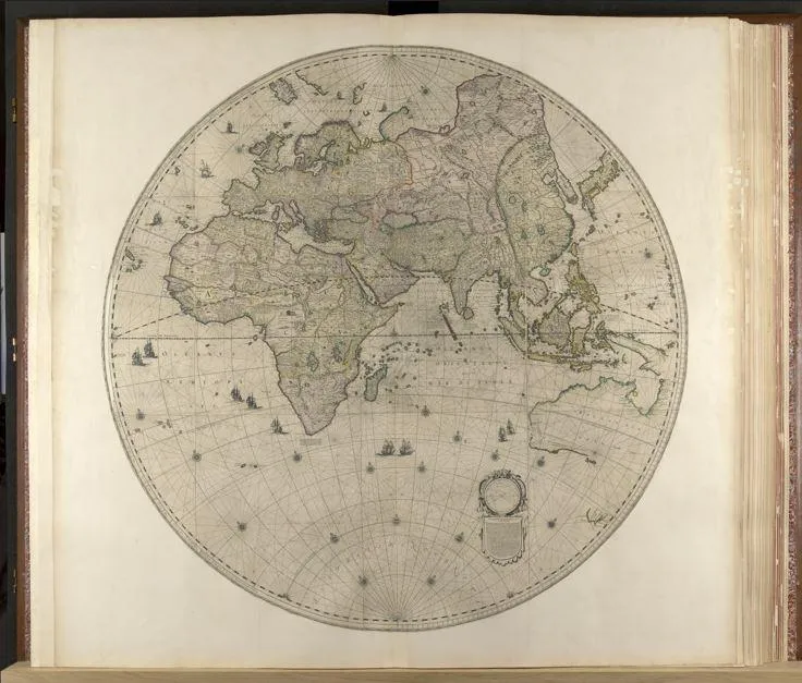
Cover image: Part of a 1648 world map containing previously confidential Dutch coastal data of Australia. The map was presented to Charles II of England (Maps K.A.R.1,2)/Joan Blaeu, world map, 1648 (Maps K.A.R.1,2) © British Library Board
(For comments and suggestions, e-mail TFCN at [email protected].)
